![](/images/other/stat-length.png)
![Tour Mountainbike La Garde-Adhémar - Circuit Rouge n°11 le Creux Rouge - Photo](https://media.geolcdn.com/t/1900/400/09b761d5-38ff-4e8e-b09f-1967fac22b19.png&format=pjpeg&maxdim=2)
Circuit Rouge n°11 le Creux Rouge
lespoulpes
Benutzer
![Länge](/images/other/stat-length.png)
![Maximale Höhe](https://static1.geolcdn.com/siteimages/upload/files/1508320355ic_sort_altitude_max_24dp.png)
![Positive Höhendifferenz](https://static1.geolcdn.com/siteimages/upload/files/1508320355ic_sort_den_pos_24dp.png)
![Km-Effort](/images/other/stat-length.png)
![Min. Höhe](https://static1.geolcdn.com/siteimages/upload/files/1508320355ic_sort_altitude_min_24dp.png)
![Negative Höhendifferenz](https://static1.geolcdn.com/siteimages/upload/files/1508320355ic_sort_den_neg_24dp.png)
![Boucle](https://static1.geolcdn.com/siteimages/upload/files/16400158638029165_repeat_loop_refresh_sync_direction_icon.png)
![Mountainbike](https://static1.geolcdn.com/sitytour/trail-icons/202.png)
1h57
Schwierigkeit : Schwierig
![Scannen Sie diesen QR-Code, um die Tour in der SityTrail-Anwendung zu öffnen](https://capi.geolives.com/qq0zvz2zws4bq2lad0pu/sitytour/trails/2437679/qr.png?size=200)
Kostenlosegpshiking-Anwendung
Über SityTrail
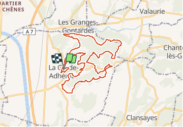
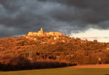
Tour Mountainbike von 24 km verfügbar auf Auvergne-Rhone-Alpen, Drôme, La Garde-Adhémar. Diese Tour wird von lespoulpes vorgeschlagen.
Beschreibung
11 - DIFFICILE | 24 km | 460 m déniv. | 2h15 Départ : La Garde-Adhémar
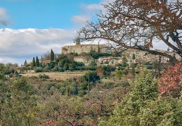
Avec ce parcours pour vététistes aguerris, vous sillonnerez les sentiers du plateau de La Garde-Adhémar qui vous feront profiter des paysages typiques de la région. Vous passerez au lieu du " Creux Rouge ", découvrirez le Val des Nymphes et sa chapelle. De nombreuses monotraces vous emmeneront au lieu dit " des Borias " près des cuves lapidaires. Le retour sera encore parsemé de belles montées et de lieux insolites...
Parcours :
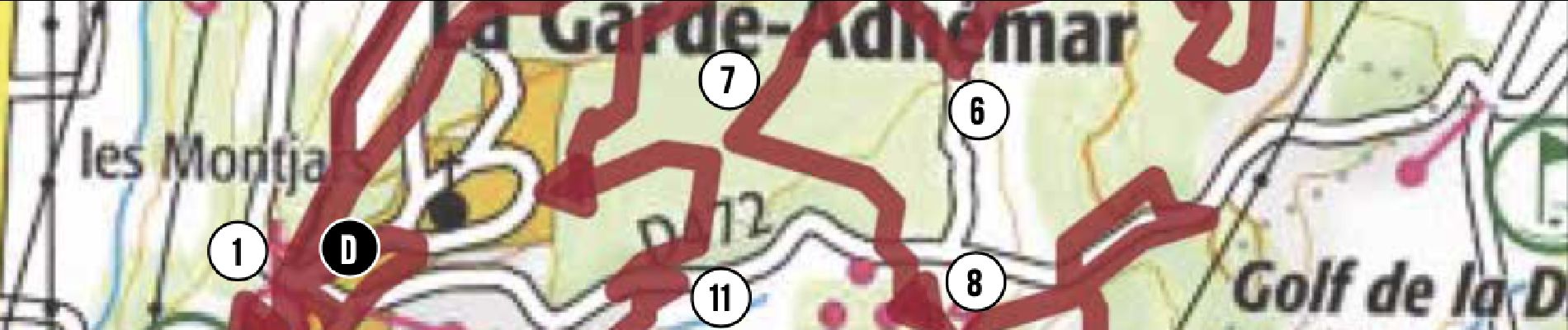
DÉPART : Parking des Montjars. Suivre le balisage n°11. Traverser le village (point d’eau), passer sous un porche et atteindre les rochettes (alt.175 m).
1. Prendre à droite le chemin carrossable. Plus loin, tourner à gauche sur une monotrace en sous bois au profil descendant.
1,2 km
2. Tourner à droite pour suivre un sentier ludique qui devient technique dû aux nombreux cailloux dans une descente. En bas, continuer à droite sur un beau sentier.
3,6 km
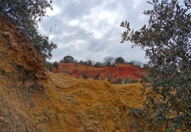
3. Prendre à droite un sentier qui monte au " Creux rouge " portant bien son nom. De bons coups de pédales sont à prévoir !
5,8 km
4. Plus haut, quitter le chemin principal et suivre à gauche un sentier technique en montée au milieu des chênes en suivant les bonnes trajectoires !
6,7 km
5. S’engager à gauche dans une descente pour rejoindre un magnifique sentier en sous- bois qui débouche dans une clairière. Le emonter jusqu’à un chemin, puis plus loin, redescendre une monotrace virevoltante jusqu’à atteindre Romany (alt.162 m).
7,5 km
6. À droite, prendre un sentier ludique au profil montant. Plus haut, tourner à gauche sur une monotrace enchanteresse et se laisser glisser jusqu'aux Buissières (alt.175 m).
10,4 km
7. Descendre à gauche la piste pour atteindre une route et le Val des Nymphes (alt.155 m). Attention voitures ! Revenir sur la route et à droite, atteindre le Val des Nymphes Sud.
11,6 km
8. Prendre à gauche un sentier, pour faire le tour des " Borias", aux monotraces enchanteresses qui vous ramènerons en suivant le balisage n°11 aux cuves Lapidaires (alt. 165 m).
12,5 km
9. Continuer ce sentier qui par endroit devient technique (marches, gros cailloux). Descendre la colline, puis rejoindre le Rieu (alt.100 m).
15,9 km
10. Continuer par une descente et une remontée pavée abrupte (100 m). En haut, s’engager à droite sur un sentier joueur et rejoindre une route au poteau " Galerie Linard " (alt.150 m).
18,5 km
11. Continuer à gauche (200 m), puis prendre à droite un sentier en montée. Plus loin, prendre à gauche une monotrace (balisage n°11) dans les chênes verts et atteindre un immense cairn.
20 km
12. Prendre le sentier à gauche qui remonte. Atteindre un chemin, puis une petite route. Redescendre en direction de La Garde-Adhémar.
22 km
ARRIVÉE : Parking des Montjars.
24 km
Ort
Kommentare
Touren in der Umgebung
![Tour Wandern La Garde-Adhémar - La Garde-Adhemar Le Val des Nymphes Les Ocres 13km. - Photo](https://media.geolcdn.com/t/375/260/f22fd23a-4662-459b-bd1b-f7844383ab69.jpg&format=jpg&maxdim=2)
![Wandern Wandern](https://static1.geolcdn.com/sitytour/trail-icons/101.png)
Wandern
![](/images/other/stat-length.png)
![](https://static1.geolcdn.com/siteimages/upload/files/16400158638029165_repeat_loop_refresh_sync_direction_icon.png)
![Tour Wandern Clansayes - SityTrail - Clansayes Le Rouvergue 6km - Photo](https://media.geolcdn.com/t/375/260/de3feb6f-5587-4e87-a580-1261cf3df48e.jpg&format=jpg&maxdim=2)
![Wandern Wandern](https://static1.geolcdn.com/sitytour/trail-icons/101.png)
Wandern
![](/images/other/stat-length.png)
![](https://static1.geolcdn.com/siteimages/upload/files/16400158638029165_repeat_loop_refresh_sync_direction_icon.png)
![Tour Wandern La Garde-Adhémar - La Garde-Adhemar Val- des-Nymphes. 8,5km - Photo](https://media.geolcdn.com/t/375/260/05b3cab3-21bf-4624-90c5-6a3af96daa1d.jpg&format=jpg&maxdim=2)
![Wandern Wandern](https://static1.geolcdn.com/sitytour/trail-icons/101.png)
Wandern
![](/images/other/stat-length.png)
![](https://static1.geolcdn.com/siteimages/upload/files/16400158638029165_repeat_loop_refresh_sync_direction_icon.png)
![Tour Wandern Roussas - Roussas le Vernet 10km. - Photo](https://media.geolcdn.com/t/375/260/69de5ff3-2ab5-4bbd-b379-bc7253ad9aad.jpg&format=jpg&maxdim=2)
![Wandern Wandern](https://static1.geolcdn.com/sitytour/trail-icons/101.png)
Wandern
![](/images/other/stat-length.png)
![](https://static1.geolcdn.com/siteimages/upload/files/16400158638029165_repeat_loop_refresh_sync_direction_icon.png)
![Tour Wandern Roussas - Roussas Panassas 8 km - Photo](https://media.geolcdn.com/t/375/260/daa93b3b-e486-4ddd-9c21-8f099d0a496e.jpg&format=jpg&maxdim=2)
![Wandern Wandern](https://static1.geolcdn.com/sitytour/trail-icons/101.png)
Wandern
![](/images/other/stat-length.png)
![](https://static1.geolcdn.com/siteimages/upload/files/16400158638029165_repeat_loop_refresh_sync_direction_icon.png)
![Tour Wandern La Garde-Adhémar - Autour de La Garde-Adhémar - Photo](https://media.geolcdn.com/t/375/260/36cc3a9b-6c5f-44d5-8991-b48f1fc96c15.jpg&format=jpg&maxdim=2)
![Wandern Wandern](https://static1.geolcdn.com/sitytour/trail-icons/101.png)
Wandern
![](/images/other/stat-length.png)
![](https://static1.geolcdn.com/siteimages/upload/files/16400158638029165_repeat_loop_refresh_sync_direction_icon.png)
![Tour Wandern Clansayes - 2022-06-24_19h24m07_Clansayes Le Rouvergue 11km.gpx.xml - Photo](https://media.geolcdn.com/t/375/260/89c952dc-9c57-4311-93c9-63263f0349ef.jpg&format=jpg&maxdim=2)
![Wandern Wandern](https://static1.geolcdn.com/sitytour/trail-icons/101.png)
Wandern
![](/images/other/stat-length.png)
![](https://static1.geolcdn.com/siteimages/upload/files/16400158638029165_repeat_loop_refresh_sync_direction_icon.png)
![Tour Wandern Clansayes - 2022-05-26_08h43m46_Clansayes Le Rouvergue 8km.gpx.xml - Photo](https://media.geolcdn.com/t/375/260/00183d4b-7799-462e-b9b9-5e3d9f7cb776.jpg&format=jpg&maxdim=2)
![Wandern Wandern](https://static1.geolcdn.com/sitytour/trail-icons/101.png)
Wandern
![](/images/other/stat-length.png)
![](https://static1.geolcdn.com/siteimages/upload/files/16400158638029165_repeat_loop_refresh_sync_direction_icon.png)
![Tour Wandern Clansayes - SityTrail - 2656269 - chantemerle-clansayes-15km - Photo](https://media.geolcdn.com/t/375/260/10944c4f-f60a-41d6-ab1f-e2a3431a6612.jpg&format=jpg&maxdim=2)
![Wandern Wandern](https://static1.geolcdn.com/sitytour/trail-icons/101.png)
Wandern
![](/images/other/stat-length.png)
![](https://static1.geolcdn.com/siteimages/upload/files/16400158638029165_repeat_loop_refresh_sync_direction_icon.png)